Oceanic Currents-महासागरीय धाराएँ
The broad river like streams which flow inside oceans are known as currents.
Reasons –
- Difference in temperature i.e. from hot places to cold places.
- Difference in salinity i.e. from high saline to low saline places.
Type of Ocean Currents
1. Surface Currents-Surface Circulation.
These waters make up about 10% of all the water in the ocean. These waters are the upper 400 meters of the ocean.
2. Deep Water Currents-
Thermohaline Circulation(By temperature (thermo) and salinity (haline)
These waters make up the other 90% of the ocean. These waters move around the ocean basins by density driven forces and gravity..
The density difference is a function of different temperatures and salinity .These deep waters sink into the deep ocean basins at high latitudes where the temperatures are cold enough to cause the density to increase.
Ocean currents can also be classified based on temperature:
- Cold currents: It brings cold water into warm water areas. These currents are usually found on the west coast of the continents in the low and middle latitudes (true in both hemispheres) and on the east coast in the higher latitudes in the Northern Hemisphere.
- Warm currents: It brings warm water into cold water areas and is usually observed on the east coast of continents in the low and middle latitudes (true in both hemispheres).
Types of forces-
Currents are influenced by two types of forces.
1. Primary Forces--start the water moving.
1. Solar Heating 2. Winds 3. Gravity 4. Coriolis
2. Secondary Forces--influence where the currents flow-
A combination of centrifugal and Coriolis forcesdrive the secondary circulation of turbidity currents in sinuous channels, and hence determine where erosion and deposition of sediment occur.
-Solar heating cause water to expand.
Near the equator the water is about 8 centimeters high than in middle latitudes. This cause a very slight slope and water wants to flow down the slope.
-Winds blowing on the surface of the ocean push the water. Friction is the coupling between the wind and the water's surface.
-Gravity will tend to pull the water down the "hill" or pile of water against the pressure gradient.
-Coriolis Force intervenes and cause the water to move to the right (in the northern hemisphere) around the mound of water.
Gyres–
These large mounds(heap) of water and the flow around them are called Gyres. The produce large circular currents in all the ocean basins.
Ekman Transport –
Ekman Transport is the net motion of fluid as the result of a balance between Coriolis and turbulent drag forces.
Coastal upwelling occurs where Ekman transport moves surface waters away from the coast;
Speed of Ocean currents-
Ocean currents are the slow-surface movement of water in the ocean. The speed range is from a few centimetres per second to as much as few metres per second.
The Gulf Stream is the fastest ocean current in the world with peak velocities near 2m/s.
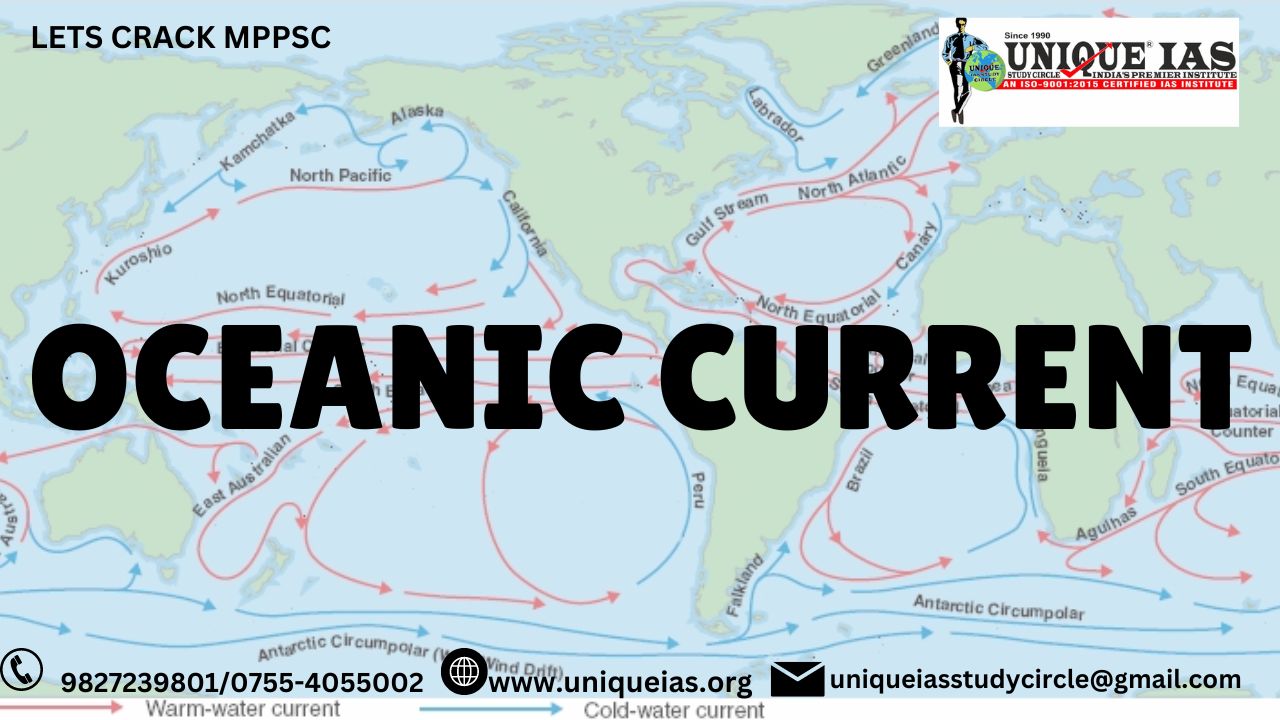
Major currents of Pacific Ocean –
Name of current Nature
- Oya – Shivo (kuril) cu. Cold
- Kura – Shivo cu. Hot
- Eastern Australian cu. Hot
- Alaska cu. Hot
- California cu. Cold
- Ham bolt cu. Cold
- Al – Nino cu. Hot cu. Between cold current(Peru coast)
creates AlNino effect –disturbances in weather .
LA – NINA cur.
Reverse of Al- Nino
Major currents of Atlantic ocean –
Name Nature
- Labradoor cu. Cold
- Gulf stream cu. Hot
Above both currents meets at new found land. Fog is always present and it is one of highest fishing centre in the world.
- Brazil cu. Hot
- Falk land cu. (U.K.) Cold
- Canary cu. Cold
- Beguena cu. Cold
Falk land -Argentina invaded the islands on 2 April 1982, using special forces,
Major currents of Indian Ocean –
Name Nature
Western – Australian cu. Cold
Mozambique cu. Hot
Agulhascu. Hot
Monsoon cu. Hot
El Niño
Southern Oscillation (ENSO) –
Southern Oscillation (ENSO) is an irregularly periodical variation in winds and sea surface temperatures over the tropical eastern Pacific Ocean, affecting much of the tropics and subtropics.
The warming phase is known as El Niño and the cooling phase as La Niña.
Southern Oscillation (DakshniDolan )is the accompanying atmospheric component, coupled with the sea temperature change:
- El Niño is accompanied with high, and
-La Niña with low air surface pressure in the tropical western Pacific.
The two periods last several years each (typically three to four) and their effects vary in intensity.
The two phases relate to the Walker circulation, discovered by Gilbert Walker during the early twentieth century.
Strong Walker circulation causes a La Niña–
An especially strong Walker circulation causes a La Niña, resulting in cooler ocean temperatures due to increased upwelling in the eastern pacific ocean .
Weak Walker circulation causes El Niño -
The Walker circulation is caused by the pressure gradient force that results from a high pressure system over the eastern Pacific ocean, and a low pressure system over Indonesia.
When the Walker circulation weakens or reverses, an El Niño results, causing the ocean surface to be warmer than average, as upwelling of cold water occurs less or not at all.
Mechanisms that cause the oscillation remain under study. The extremes of this climate pattern's oscillations cause extreme weather (such as floods and droughts) in many regions of the world.
Developing countries dependent upon agriculture and fishing, particularly those bordering the Pacific Ocean, are the most affected.
El Nino Modoki: (IAS EXAM)
El Nino can be classified into two types—
-Traditional El Nino which is characterized by strong anomalous warming in the eastern equatorial Pacific and the
- El Nino Modoki that is associated with strong anomalous warming in the central tropical Pacific and cooling in the eastern and western tropical Pacific.
El Nino Modoki forms in Central Pacificand it does result in greater number of hurricanes with greater frequency.
Normal El Nino results in diminished hurricanes in Atlantic Ocean.
El Nino warming is stronger in the Central Pacific rather than the Eastern Pacific, a phenomenon known as El Nino Modoki (Modoki is a Japanese term for "similar, but different").
It was hypothesized that El Nino Modoki drives a climate pattern known as the North Pacific Gyre Oscillation (NPGO).
Q-Why are cold currents usually found on the West Coast of the continent at low and middle latitudes.(Eastern Coast of the continent at High latitudes)-Its related to planetary winds. In tropical region, trade winds flow from east to west. With these winds, the upper water leyer of the Eastern part of ocean also moves towards West. - Water Upwelling takes This causes release of pressure in the Eastern part and Water Upwelling takes place in that part. Upwelled water is relatively cold in nature, thats why it causes “Cold currents” in the Eastern part of Oceans (which is Western coast of continents). Q-Why are HOT currents usually found on the Eastern Coast of the continent at low and middle latitudes. -Downwelling occurs where surface currents converge. -The converging water has to go down, so the surface water sinks. -Surface water is usually low in nutrients, downwelling leads to low productivity zones. |
Advantages of Oceanic current
Fishing *Navigation Hot currents when reach the cold places, produce moderate temperature. They don’t allow coast to freeze. Hence, they make the cold coast navigable throughout the year and Vice – versa for hot places.
Disadvantage-
-Ocean currents have no physical environmental damage.
-There is, however, human damage.
-Bad weather causing the pattern of the waves to change can bring drownings, rip tides, or rough seas which are bad for shipping.
Impact of ocean currents on coastal environment and marine life-
Ocean currents are one of the major condition that affects climate and weather of a region including the ecosystem of coast.
Ocean currents - impact on coastal environment and marine life
-Marine productivity
Ocean currents have great impact on the biomass production in a region. The currents are responsible for increasing or decreasing marine organisms on the coast.
The warm currents are rich in organic contents due to upwelling and cold currents are oxygen supportive.
The region where these currents meet is one of the most productive region in terms of fishing activities.
Ex: The Japanese coast is suitable for large-scale fishing due to mixing of Oyashio and Kuroshio currents.
-Desert formation:
Cold ocean currents inhibit rains and cause arid conditions to create deserts.Eg.Atacama desert of South America, Mojave desert of North America.
-Rainfall patterns
The ocean currents have ability to influence rainfall patterns owing to their ability to attract or repel warm winds.
The coast having presence of cold currents usually inhibit onshore winds, resulting in creating desert like conditions.
Ex: The North-western coast of Africa is flanked by cold currents called Canary currents. These currents prevent warm air from ascending near the coast leading to formation of Sahara desert.
Fog Formation:
The meeting of the warm and the cool currents results in the formation of fog.
The ship's face danger due to the fogs caused by the meeting of the warm currents with the cold currents.
This has resulted in the wreckage of many ships in the past as they are not able to view icebergs due to poor visibility.
Trade and Commerce:
Currents help ships to sail if they follow the directions of the currents.
Many warm currents keep the ports of Europe ice free even during the winters. This helps in trade and commerce.
Violent Storms:
At times the meeting line of a warm and a cold current may result in a violent storm.
The hurricanes which occur off the coast of the U.S.A. follow the line where the Gulf Stream merges with the Labrador Current.
-Sea ice formation
Ocean currents and masses are responsible for formation of sea ices at higher latitudes. The region of temperate climates will suffer from sea ice formation which affects coastal navigation leading to loss of economic activity.
Warm currentsprevent formation of sea ice even though the region is close to poles.
Ex: Canadian ports located near Newfoundland suffer from sea ice formation due to presence of cold Labrador current.
Whereas the ports of Norway and United Kingdom do not experience sea ice inspite of them located in higher latitudes than Canadian ports. This is due to warm gulf stream.
-Local climate
Coastal regions on the globe may experience higher and lower temperatures mainly due to warm and cold currents.
This will have a large impact on locally observable climatic conditions.
Ex: Cities of New York and Lisbon are located on the same latitudes but both experience different weather conditions. This is because New York is flanked by cold current and Lisbon by warm current.
Though the presence of water mass and ocean currents both impact coastal environments- ocean currents produce more dramatic and consistent impacts that touch the lives of people and animals than the water masses would have.
Water masses can lead to the formation of cyclone in India in pre and post-monsoon times.
Warm water masses increase the growth of algae (Red Tides), thereby affecting the productivity of marine life whereas, the cold-water masses with nutrients helps in plankton growth which in turn increase the productivity of marine life.
Intermixing of cold and warm water are well suited for the fishing. For Example- Cold Labrador with warm North Atlantic Drift at Grand Bank.
Ocean currents mix coastal environment ,which acts as a temperature equalizer, nutrients recycler.
|
‘Dead Zones’ in marine ecosystem. What are Dead Zones? When the oxygen level of an area of the water body becomes low, that area is called Dead Zone. This area is also known as Hypoxic Area. Normally the concentration of dissolved oxygen in oceanic water is 9 ml of oxygen/L in the polar region and 4 ml of oxygen/ L in the equatorial region. It helps to make a balance of Marine eutrophication. The most serious threat from eutrophication is seen when the dissolved oxygen (DO) levels in bottom waters are started decreasing. Dead Zones are not a permanent situation in an area, if their causes are eliminated or reduced, Marine life will increase gradually. Causes of Dead Zone-Raise of Temperature
When temperature increase by 1°C the dissolved oxygen of ocean water decrease by 2%. Oxygen Depletion
Nutrient Pollution:
Impact of Dead Zone:Impact on Global WarmingWhen oxygen Depletion occurs, it increases the formation of nitrous oxide. N²O is one of the important components of greenhouse gas and among the greenhouse gases, it is 300 times more powerful than carbon dioxide. So, due to the increase of nitrous oxide in the environment, global warming also increases as well as the average temperature of the ocean water also increases. Impact on CoralCorals play an important role in the Marine ecosystem. It works as a shelter for many oceanic creatures. Corals cannot survive in the ocean where the average dissolved oxygen is less than 2 ml/lit. Impact on HumanThe human also suffers at the economic level due to the Dead Zone. In the year 2016, when a toxic tide hit the coastal region of Chile. It smashed 20% of salmon fish. For this incident, Chile faced a loss of 1 billion dollars. This incident happened due to the Dead Zone situated nearby Chile. The toxic water came from this region which polluted the coastal water of the country Chile. Impact on FishDead Zone is working as an invisible Dead trap. There is no way to escape the Marine creature. Even fish cannot detect the Dead Zone before entering the region. Due to lack of oxygen, when fishes enter the Dead Zone, at first they lost consciousness. Prevention or Reduce of Dead ZonesDead Zone is a reversible process. Once the causes are removed, the zone becomes habitable for Marine species. For example, many regions of the Black Sea becomes Dead Zone. But after the 1990s, the Dead Zones of this area disappeared. The Rhine river became the Dead Zone during the time of the industrial revolution. But, when sewage and industrial emissions are reduced, the Dead Zones of the Rhine river disappeared. Now, in the world, there is 14 Hypoxic region which is recovered.
Q-What are the consequences of spreading of …‘Dead Zones’ on marine ecosystem? IAS-2018 |
|
Question asked in IAS Exam - Q-Consider the following factors? 1. Rotation of the Earth 2. Air pressure and wind 3. Density of ocean water Which of the above factors influence the ocean currents? (a) 1 and 2 only (b) 1, 2 and 3 (c) 1 and 4 (d) 2, 3 and 4… ANSWER: (B) (b) 1, 2 and 3 Q-The most important fishing grounds of the world are found in the regions where:(IAS-Exam-2013) (a) warm and cold atmospheric currents meet (b) rivers drain out large amounts of fresh water into the sea (c) warm and cold oceanic currents meet (d) continental shelf is undulating Ans-(c) warm and cold oceanic currents meet Q. Consider the following statements(IAS-Exam)
Which of these statements are correct? (a) 1 and 2(b) 2, 3 and 4(c) 1, 3 and 4(d) 1, 2, 3 and 4 Ans-(d) 1, 2, 3 and 4
|
.jpg)


.jpg)
.jpg)

.jpg)